Mount Tangkuban Parahu
Overview

Subang, West Java
6.77°S
107.6°E
2084 m
6837 ft
Stratovolcano
2019 CE
Literature and Analysis
2019 Jul 26 – 2019 Sep 17
| Date | Event Type | Fatalities | VEI (Explosivity Index) | Level | Event Remarks |
| 2019 Jul 26 | – | – | 1 | – | – |
2013 Oct 5
| Date | Event Type | Fatalities | VEI (Explosivity Index) | Level | Event Remarks |
| 2013 Oct 5 | Phreactic Activity | – | 1 | – | PVMBG reported a phreatic eruption at 0621. |
2013 Feb 21 – 2013 Mar 06
| Date | Event Type | Fatalities | VEI (Explosivity Index) | Level | Event Remarks | Reference |
| 2013 Feb 21 | Plume | – | 1 | – | Ash emmision rose from ratu crater. | [1] |
| 2013 Feb 24 – 2013 March 6 |
Deformation (Deflation) | – | 1 | – | Deflation was detected from 24 February through early March. | [1] |
| 2013 Feb 28 – 2013 Mar 6 |
Ash plume and phreatic activity | – | 1 | – | Eruption Occured on February 28 and during march 4-6 plumes reached 100 m above the crater. | [1] |
| 2013 Mar 4 – 2013 Mar 6 |
Ash plume | – | 1 | – | 500 m above the crater and 30 m above the Ratu Crater on Mar 6 | [1] |
1983 Sept 14
| Date | Event Type | Fatalities | VEI (Explosivity Index) | Level | Event Remarks | Reference |
| 1983 Sept 14 | Ash, Phreatic activity | – | 1 | – | [1] |
1969 Jul 20 – 1969 Oct 20
| Date | Event Type | Fatalities | VEI (Explosivity Index) | Level | Event Remarks | Reference |
| 1969 Jul 20 |
Ash, Phreatic activity |
– | 1 | – | Weak or small | [1] |
1967 Jul 16
| Date | Event Type | Fatalities | VEI (Explosivity Index) | Level | Event Remarks | Reference |
| 1967 Jul 16 | Phreatic activity | – | 1 | – | Weak or small | [1] |
1965 Feb 16 – 1965 Oct 16
| Date | Event Type | Fatalities | VEI (Explosivity Index) | Level | Event Remarks | Reference |
| 1965 Feb 16 – 1965 Oct 16 |
Phreatic activity | – | 1 | – | – | [1] |
1961 Jul 16 – 1961 Aug 1
| Date | Event Type | Fatalities | VEI (Explosivity Index) | Level | Event Remarks | Reference |
| 1961 Jul 16 – 1961 Aug 1 |
Phreatic activity | – | 1 | – | – | [1] |
1957 Jan 16
| Date | Event Type | Fatalities | VEI (Explosivity Index) | Level | Event Remarks | Reference |
| 1957 Jan 16 | Phreatic activity | – | 1 | – | – | [1] |
1952 Jul 4 – 1952 Jul 11
| Date | Event Type | Fatalities | VEI (Explosivity Index) | Level | Event Remarks | Reference |
| 1952 Jul 4 | Ash, Phreatic activity | – | 1 | – | Weak or small | [1] |
1929 May 20
| Date | Event Type | Fatalities | VEI (Explosivity Index) | Level | Event Remarks | Reference |
| 1929 May 20 | Phreatic activity | – | 0 | – | – | [1] |
1926 Mar 1 – 1926 Jul 9
| Date | Event Type | Fatalities | VEI (Explosivity Index) | Level | Event Remarks | Reference |
| 1926 Mar 1 | Ash, Phreatic activity, Blocks, Crater | – | 1 | – | Summit (crater) | [1] |
1910 Apr 7 – 1910 May
| Date | Event Type | Fatalities | VEI (Explosivity Index) | Level | Event Remarks | Reference |
| 1910 Apr 1 | Ash, Phreatic activity, Blocks, Explosion, Earthquakes (undefined) | – | 2 | – | – | [1] |
1896 May 22
| Date | Event Type | Fatalities | VEI (Explosivity Index) | Level | Event Remarks | Reference |
| 1896 May 22 | Ash, Phreatic activity |
– | 2 | – | – | [1] |
1846 May 27
| Date | Event Type | Fatalities | VEI (Explosivity Index) | Level | Event Remarks | Reference |
| 1846 May 27 | Explosion, Pyroclastic flow, Lahar, Property damage |
– | 2 | – | – | [1] |
1842
| Date | Event Type | Fatalities | VEI (Explosivity Index) | Level | Event Remarks | Reference |
| 1842 | Phreatic activity | – | – | – | Uncertain | [1] |
1829 Apr 1
| Date | Event Type | Fatalities | VEI (Explosivity Index) | Level | Event Remarks |
| 1829 Apr 1 | Ash, Plume | – | 2 | – | – |
1826 Oct 11
| Date | Event Type | Fatalities | VEI (Explosivity Index) | Level | Event Remarks |
| 1826 Oct 11 | Phreatic activity | – | 2 | – | – |
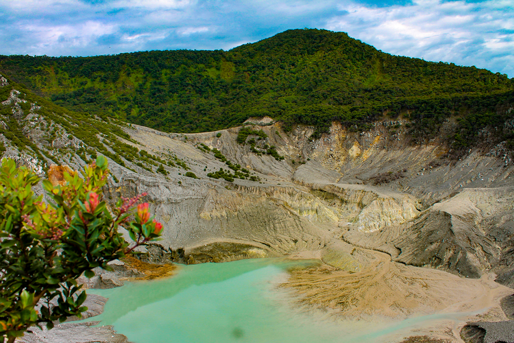
North of Bandung the morphology is determined by the Sunda-Tangkuban Perahu volcanic complex, including the large Sunda caldera and other remnants of older volcanism. The conspicuous flat summit of the active Tangkuban Perahu volcano, which formed inside the Sunda caldera, rises to some 2000 m. To the east and northeast, in the Bukanegara area, older volcanics are strongly affected by faulting and gravitational collapse. A relatively flat but dissected zone south and east of Tangkuban Perahu and and adjacaent to the town of Lembang is indicated as the Lembang surface or Lembang plain. Southwards, it is bordered abruptly by the Lembang fault scarp, running practically East-West. The normal faulting is ascribed to magmatic depletion as a result of the eruptions of the Sunda and Tangkuban Perahu volcanoes ([2] – [5]).
Tangkuban Parahu is a volcano formed in the youngest phase of the continuation of the Sunda – Tangkuban Parahu volcanic system which has a long and complex geological history. Soetoyo and Hadisantono (2005) classified the volcanic rocks of Tangkuban Parahu into seven (seven) groups of volcanic units, ranging in age from old to young. These groups include the Tertiary Volcano, Pre-Sunda Volcano, Sunda Volcano, Kandangsapi Volcano, Dano Volcano, Bukitunggul – Manglayang Cone Group, and Tangkuban Parahu Volcano. Other non-volcanic rock deposits include lake deposits and fluviatile rocks. Because they are not covered by earlier volcanic deposits, volcanic rocks thought to be Tertiary in age are visible on the south-west lower slope and the northeast middle slope, generating a hill bulge morphology [6].
Based on tephrachronological analysis, the volcanism of the Sunda – Tangkuban Parahu Volcano Complex is grouped into 4 phases of volcanism, from old to young, namely Pre Sunda, Sunda, Tangkuban Parahu and Tangkuban Parahu. Two caldera successions produced pyroclastic flow deposits or Cisarua ignimbrites and Manglayang ignimbrites which are spread almost all over the slopes of Tangkuban Parahu. The Manglayang ignimbrites contain a number of accretionary lapilli, indicating that the paroxysm eruptions associated with the formation of the Sunda caldera were initiated by eruptions associated with phreatomagmatic systems [7].
The volcanism phase of Sunda volcano around 210-105 thousand years ago produced several lava flow units formed in the range of 210 thousand – 128 thousand years ago. These lavas are scattered on the northern slope of Tangkuban Boat [8].
According to Hartono and Koesoemadinata (1981) who compiled the stratigraphy of the North Bandung area, the oldest rocks exposed in this area are from the Cikapundung Formation, dated Lower Pleistocene, consisting of clasts, volcanic breccias, tuffs and andesite lava inserts. This unit is covered with an erosion field by the Cibeureum Formation of Upper Pleistocene-Holocene age, consisting of a repeating sequence of breccia-tuff with fragments of skoria-andesite-basalt and flint. Furthermore, the Upper Pleistocene-aged Kosambi Formation is deposited with lithologies of volcanic mudstone, volcanic sandstone, containing plant remains, locally found in parallel and cross-structured layers. Above this formation is deposited the Cikidang Formation which consists of columnar bridle-structured basaltic lavas, volcanic conglomerates, coarse, parallel-layered tuffs and volcanic breccias, this formation is Holocene in age. As the youngest deposits, loose materials of river deposits are deposited [9].
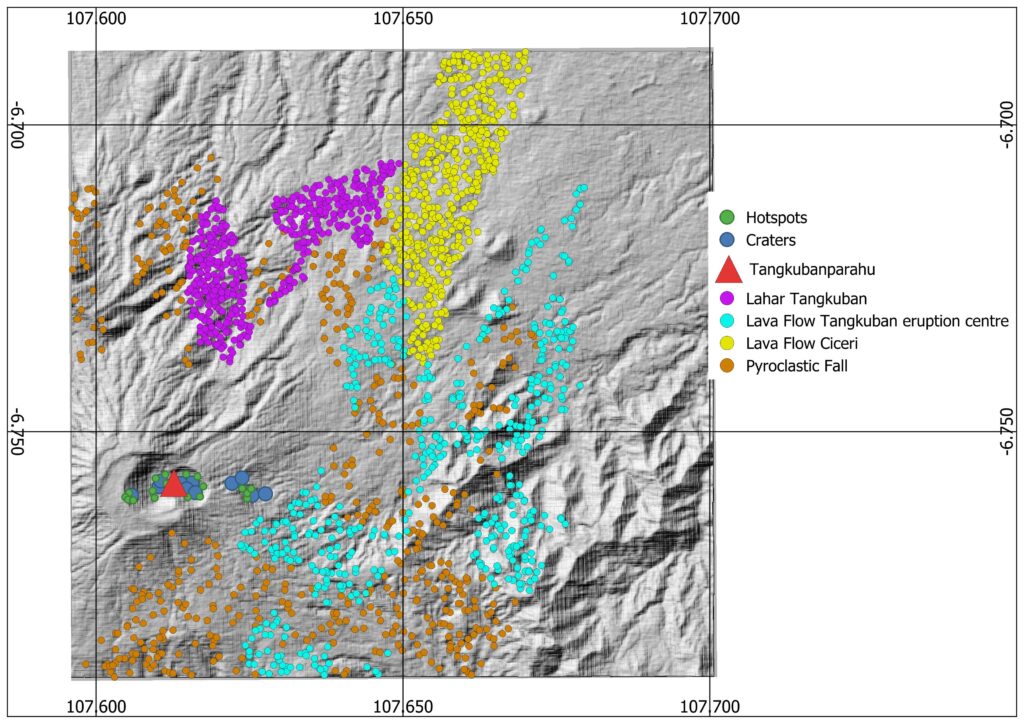
The oldest unit in this area is the Tertiary Sedimentary which consists of sedimentary materials. This unit is covered by the Pre-Sunda Volcanic Unit which consists of lava and pyroclastics. Then above the Pre-Sunda Volcanic Unit is deposited the SundaAndesite Unit aged Lower Pleistocene – Upper Pleistocene, Sunda Pyroclastic aged Late Upper Pleistocene, Tangkuban Parahu Andesite aged early Holocene, and Tangkuban Parahu Pyroclastic aged late Holocene [10]. The Quaternary Volcanic Zone produced the strato-type Tangkuban Parahu Volcano, which is one of the volcanoes that shape northern Bandung’s architecture. There are several eruption products from Post-Sunda Caldera in Figure 1 including, Tangkuban Parahu Pyroclastic Fall 1 (Tjp1), Tangkuban Parahu Lava flow 1 (Tl1), Ciceuri Lava flow (Cil1), and Tangkuban Parahu Pyroclastic Fall 3 (Tjp3) are the rock units discovered in Tangkuban Parahu [6].
Regionally, the Bandung area is part of a group of Quaternary volcanoes bounded by a volcanic triangle. In the north-west there is the Sukabumi-Padalarang strike-slip fault zone, in the north-east the Cilacap Kuningan strike-slip fault zone and in the south a descending fault bordering the Southern Mountains. The west-east trending normal fault of the Southern Mountains became the line of emergence of the Southern Mountains, while in the north the Sunda Mountain was formed, which later collapsed and was followed by west-east trending thrusting by the Lembang Fault [12].
 Volcanic features at Tangkuban Parahu.
All volcanic features in the area of Tangkuban Parahu were created using available data as a base layer. The data was compared to the geological maps from Soetoyo (2005), to locate areas of the volcanic products. The volcanic features used are based on the youngest geological age.
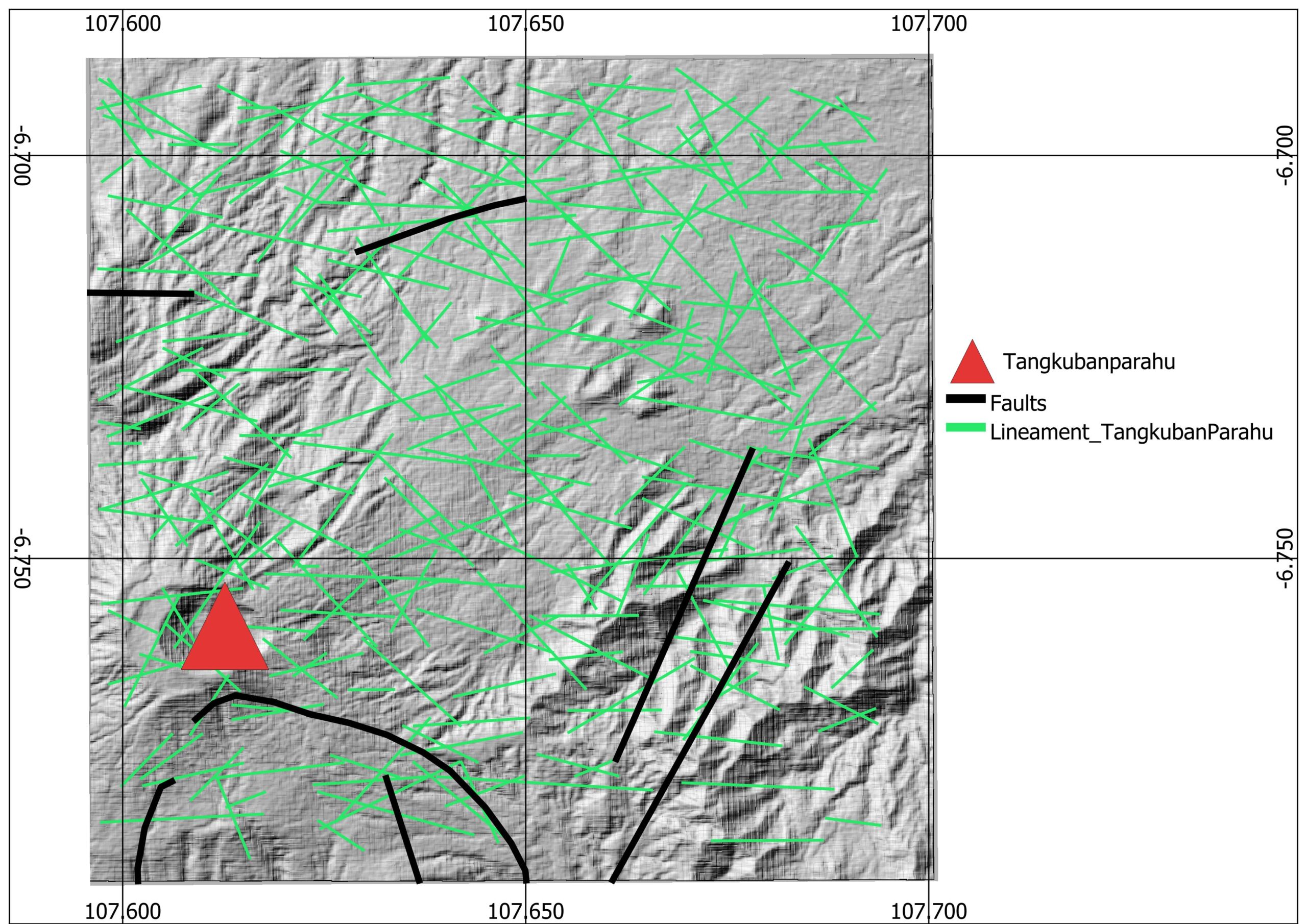
 Tectonic features around Tangkuban Parahu.
The tectonic features used consist of two structures around the Tangkuban Parahu faults and lineament features. The two shapefiles used as tectonic features are line files.

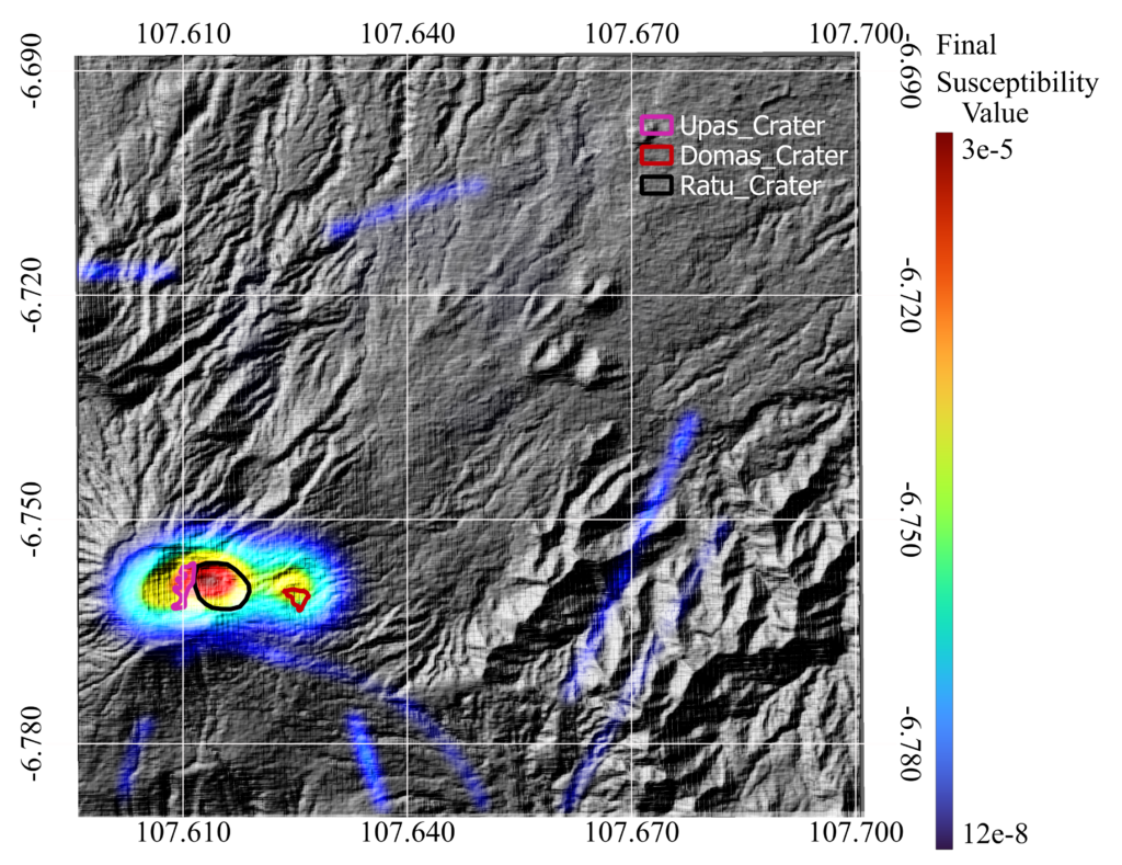
The long-term susceptibility map serves as a crucial preliminary resource for predicting eruption locations spatially and lays the groundwork for further development into spatio-temporal dynamic maps or short term susceptibility maps. The places with a higher likelihood of a vent opening are indicated on the susceptibility map, assuming that an eruption takes place within this region. Wherever the greatest likelihood is 3×10⁻⁵. The existence of areas with high eruption susceptibility is around the three main craters (Ratu, Upas, and Domas). The large susceptibility value in the crater area is reinforced by the history of eruptions that have occurred such as phreatic eruptions in the Ratu crater.
[1] Global Volcanism Program, 2024. Tangkuban Parahu (263090) in [Database] Volcanoes of the World (v. 5.2.1; 3 Jul 2024). Distributed by Smithsonian Institution, compiled by Venzke, E. https://doi.org/10.5479/si.GVP.VOTW5-2024.5.2
[2] Van Bemmelen R. W. (1934) Geologische kaart van java, I: 100,000, Blad 36, Bandoeng + Toelichting. Dienst van den Mijnbouw in Nederlandsch-Indie, Bandoeng.
[3] Van Bemmelen R. W. (1949) The Geology of Indonesia, Vol. I, IA, and IB, pp. 732, maps and appendices. Government Printing Office, Den Haag.
[4] Nossin J. J., Damen M. and Voskuil R. (1992) Morphostructural relationships in the Lembang fault area, West-Java, Indonesia. 2. Geomorph. 84, 185-201.
[5] Noor D. (1992) Applications of aerospace imagery to the study of morphostructural landforms and volcanism in the Sunda Volcanic Complex, West Java, Indonesia. M.Sc. thesis, ITC, Enschede.
[6] Soetoyo and Hadisantono, R.D., 2005, Geological Map of Tangkuban Parahu Volcano, Bandung, West Java, Directorate of Vulcanology.
[7] Kartadinata, M.N., 2005, Tephrochronological Study on Eruptive History of SundaTangkuban Parahu Volcanic Complex, West Java, Indonesia., Desertasi Doktor, Nature System Science, Graduate School of Science and Engineering, Kagoshima University, Japan.
[8] Sunardi, E., and Kimura, J., 1998. Temporal chemical variation in late Cenozoic volcanic rocks around Bandung Basin, West Java Indonesia. Journal Mineralogy, Petrology, Economic Geology, Vol. 93, p.103128.
[9] Koesoemadinata, R. P., & Hartono, D. (1981). Stratigraphy of Bandung area. IAGI Proc, Bandung.
[10] NASUTION, A., KARTADINATA, M. N., KOBAYASHI, T., SIREGAR, D., SUTANINGSIH, E.,HADISANTONO, R., & KADARSTIA, E. (2004). Geology, age dating and geochemistry of the Tangkuban Parahu geothermal area, West Java, Indonesia. Journal of the Geothermal Research Society ofJapan , 26 (3), 285-303.
[11] Katili, J. A., & Sudradjat, A. (1984). The devastating 1983 eruption of Colo Volcano, Una-Una Island,Central Sulawesi, Indonesia. Geologisches Jahrbuch. Reihe A, Allgemeine und regionale Geologie BRDeutschland und Nachbargebiete, Tektonik, Stratigraphie, Paläontologie , (75), 27-47.
